1State Key Laboratory of Networking and Switching Technology, Beijing University of Posts and Telecommunications 2Tsinghua University
3Hunan Normal University
4City University of Hong Kong
We decompose long-term remote sensing understanding into a four-level cognitive
hierarchy and instantiate it as ChronoBench (12 sub-tasks, 17,689 validated QA pairs).
Benchmarking reveals that mainstream MLLMs fall drastically behind human experts, with
Long-Term Memory as the most critical bottleneck. We then propose GeoChrono,
an MLLM that models per-location temporal trajectories, reaching 78.34% overall
accuracy — over 20 points above the best commercial model.
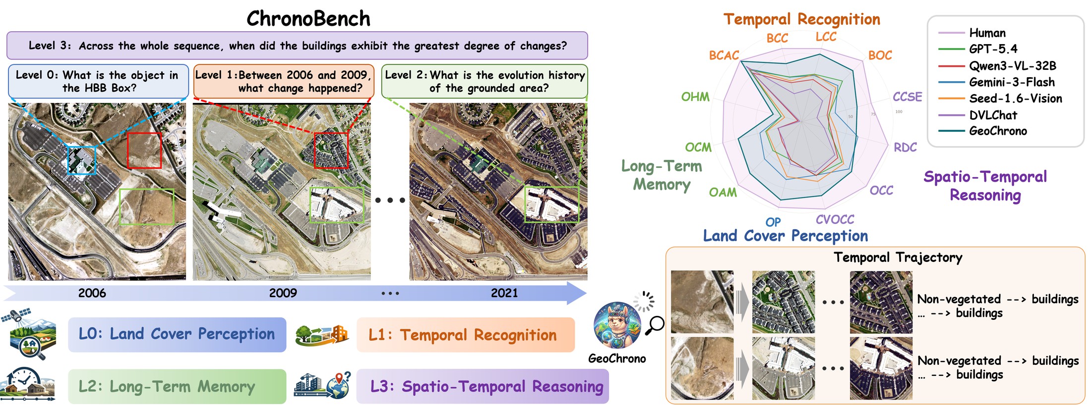
ChronoBench decomposes long-term remote sensing understanding into a four-level cognitive
hierarchy. Built upon it, GeoChrono constructs per-location temporal trajectories to model
the long-term evolution of geographic parcels, achieving state-of-the-art performance and
human-level accuracy on several sub-tasks.
A Four-Level Cognitive Hierarchy
The Earth evolves along space and time, yet most remote sensing interpretation methods
see only static snapshots or bi-temporal pairs. Understanding the continuous, long-term
trajectory of landscape transformation demands more: a model must perceive land cover,
recognize changes, memorize evolution histories, and reason across time and space. Prior
benchmarks organized around application scenarios have shown that MLLMs struggle with
long-term remote sensing, but not which underlying competency fails. ChronoBench is
built to answer exactly that: inspired by human cognition, it isolates these competencies as
four progressive levels, each framed by a core question, so that a failure at any level points
to a specific missing capability:
LEVEL 0
Land Cover Perception
What is here at a given time?
OP
LEVEL 1
Temporal Recognition
What changed between specified time points?
BCC · BCAC · LCC · BOC
LEVEL 2
Long-Term Memory
When did changes occur, and what is the complete evolution history?
OAM · OCM · OHM
LEVEL 3
Spatio-Temporal Reasoning
What can be inferred by comparing across locations and time?
CCME · RDC · OCO · CSOCO
Each level withholds one more piece of information from the model. The pivotal step is from
Level 1 to Level 2: in Level 1 the time points are given as inputs, whereas
Level 2 requires the model to recall temporal information as outputs — the
watershed between perceiving change and remembering history.
Abstract
Remote sensing offers an unparalleled vantage point for observing the Earth's long-term
surface evolution, yet it demands that a model not only perceive land cover at isolated
moments, but also track changes, memorize evolution histories, and reason across time and
space. However, existing studies lack a systematic evaluation that dissects these distinct
competencies. To fill this gap, we introduce ChronoBench, a multidimensional benchmark that
decomposes this task into four progressive cognitive levels (i.e., Land Cover Perception,
Temporal Recognition, Long-Term Memory, and Spatio-Temporal Reasoning). ChronoBench comprises
12 sub-tasks and 17,689 rigorously validated QA pairs. Extensive evaluations reveal that
mainstream MLLMs fall drastically behind human experts, with Long-Term Memory emerging as the
most critical bottleneck. Motivated by this finding, we further propose GeoChrono, an MLLM
with enhanced capabilities for tracing, memorizing, and reasoning about long-term geographic
evolution. Leveraging the physical prior that geographic parcels remain spatially fixed while
their semantics evolve, we design a Temporal Trajectory Encoder (TempEnc) that constructs
per-location temporal trajectories for dedicated land cover evolution modeling, and we
introduce a Coarse-to-Fine Token Compressor (C2FComp) that adaptively preserves dynamic
regions while compressing the static background. To support training, we also construct
ChronoInstruct, a 104K-sample instruction-tuning dataset spanning all competency levels.
GeoChrono achieves state-of-the-art performance on ChronoBench, surpassing the leading
commercial MLLMs by over 20%, while C2FComp reduces visual tokens by over 56% while retaining
94.6% of GeoChrono's performance.
The ChronoBench Benchmark
3,469
high-resolution images (1024×1024)
500
regions across 39 U.S. cities
17,689
rigorously validated QA pairs
12
sub-tasks over 4 cognitive levels
7.26
temporal frames per QA on average
104,949
ChronoInstruct training samples
Explore the 12 Sub-Tasks
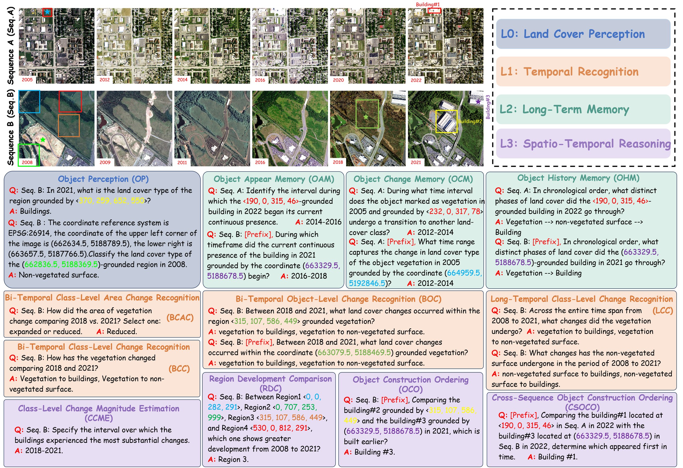
Object PerceptionOP
Identify the land cover
at a specified location and timestamp, grounded by an HBB box or geographic coordinates.
Q: In 2013, what is the land cover type of the region grounded by
⟨580, 256, 769, 611⟩? A:Vegetation
Bi-Temporal Class-Level Change RecognitionBCC
Q: How has the vegetation changed comparing 2018 and 2021? A:Vegetation → buildings; vegetation → non-vegetated surface
Bi-Temporal Class-Level Area Change RecognitionBCAC
Q: How did the area of vegetation change comparing 2005 vs. 2023?
Select one: expanded or reduced. A:Reduced
Long-Temporal Class-Level Change RecognitionLCC
Q: What changes has the non-vegetated surface undergone in the period
of 2010 to 2022? A:Non-vegetated surface → vegetation
Bi-Temporal Object-Level Change RecognitionBOC
Q: Between 2018 and 2021, what land cover changes occurred within the
region ⟨315, 107, 586, 449⟩-grounded vegetation? Select ALL that apply. A:Vegetation → buildings; vegetation → non-vegetated surface
Object Appear MemoryOAM
Q: Identify the interval during which the ⟨0, 123, 181, 326⟩-grounded
vegetation in 2021 began its current continuous presence. A:2011–2013
Object Change MemoryOCM
Q: Identify the interval during which the vegetation in 2008 grounded
by ⟨196, 791, 344, 908⟩ changed to other land cover. A:2015–2017
Object History MemoryOHM
Q: Provide the chronological sequence of distinct land cover phases
for the building in 2023 referred to by ⟨210, 155, 277, 172⟩. A:Vegetation → buildings
Class-Level Change Magnitude EstimationCCME
Q: In which interval did the vegetation undergo the sharpest change? A:2012–2014
Region Development ComparisonRDC
Q: Among Region1 ⟨58, 19, 130, 293⟩, Region2 ⟨63, 465, 148, 647⟩,
Region3 ⟨589, 130, 640, 321⟩ and Region4 ⟨700, 516, 862, 672⟩, which is the most
developed from 2010 to 2021? A:Region 3
Object Construction OrderingOCO
Q: Comparing the building#1 grounded by ⟨859, 200, 995, 278⟩ and
the building#2 grounded by ⟨0, 478, 96, 612⟩ in 2023, which is built earlier? A:Building #2
Cross-Sequence Object Construction OrderingCSOCO
Q: Comparing the building#1 at ⟨838, 79, 913, 163⟩ in Region#1 in
2021 with the building#2 at ⟨33, 943, 131, 999⟩ in Region#2 in 2023, identify which was
constructed first. A:Building #1
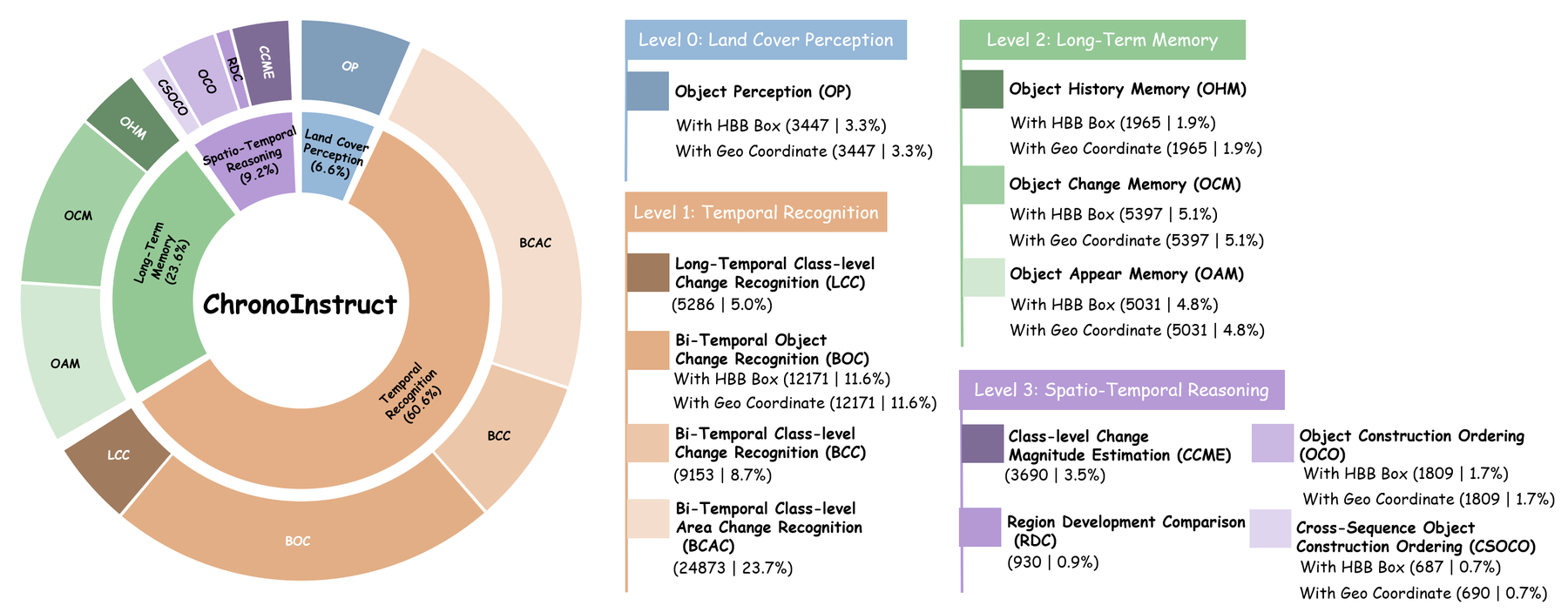
Task taxonomy of ChronoBench. Seven spatially grounded sub-tasks provide both HBB-box and
geo-coordinate variants; answers span single-choice, multiple-choice, and ordered-sequence
formats.
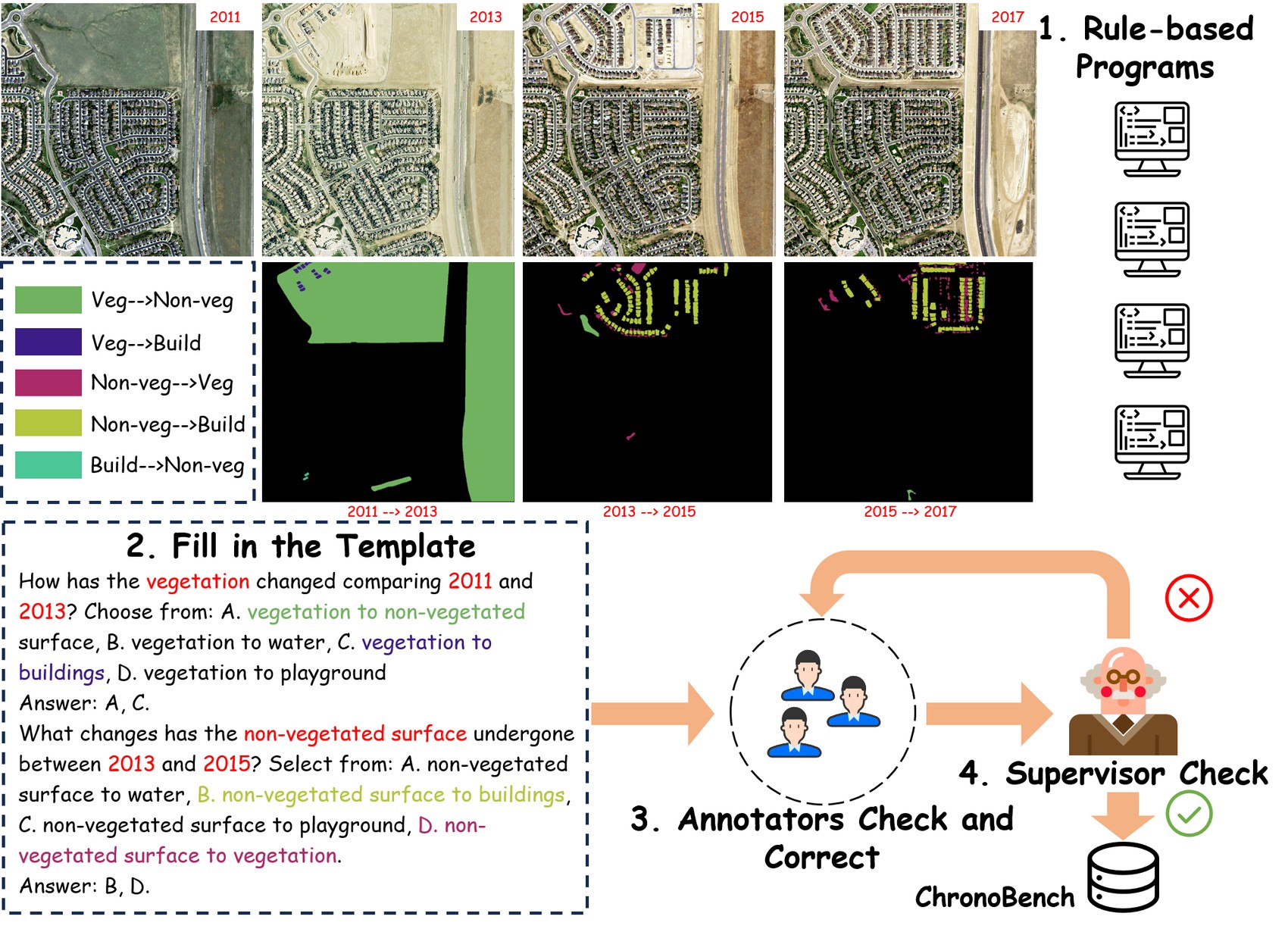
Reproducible, Rule-Based Construction
All QA pairs are generated by deterministic rule-based programs that traverse pre-existing,
human-annotated semantic change masks — no model-generated labels in the loop — followed
by a two-stage human quality-control process with independent annotators and a domain-expert
supervisor. The same pipeline scales up to ChronoInstruct, a 104,949-sample instruction-tuning
dataset with multiple-choice, short-text, and free-form natural-language answers.
Overview of the data construction pipeline.
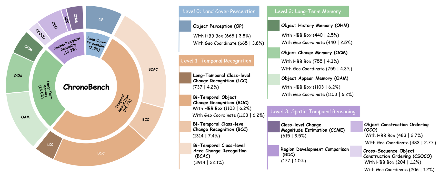
QA distribution in ChronoBench (17,689 pairs).QA distribution in ChronoInstruct (104,949 pairs).
How Well Do MLLMs Understand Long-Term Dynamics?
92.28% vs. 57.48%
A substantial human–machine gap. Human experts confirm the tasks are unambiguous
and solvable, yet the best commercial model (Gemini-3-Flash) trails them by ~35 points;
open-source models peak at 46.73%.
< 5% on OHM
Long-Term Memory is the critical bottleneck. On reconstructing complete evolution
histories, open-source models nearly collapse (0.45–4.55%) and RS domain models stay below
2.5%, despite being trained on temporal RS data.
Scaling ≠ solution
Parameter scaling is inconsistent. Growing InternVL-3.5 from 4B to 14B barely moves
memory and reasoning scores; brute-force scaling does not bridge the gap to human
cognition.
The GeoChrono Model
Temporal remote sensing sequences differ fundamentally from natural video: geographic
parcels remain spatially fixed while their semantics evolve, and only a small fraction of a
wide-area scene changes meaningfully across frames. GeoChrono turns both physical priors into
architecture: the Temporal Trajectory Encoder (TempEnc) is the core module that directly
targets the Long-Term Memory bottleneck diagnosed above, while the Coarse-to-Fine Token
Compressor (C2FComp) builds on it as a further innovation for lightweight computation in
long-temporal scenarios:
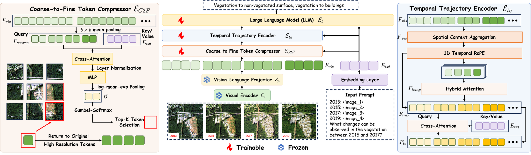
Overview of the GeoChrono framework, built upon Qwen3-VL-4B-Instruct.
Temporal Trajectory Encoder (TempEnc)
TempEnc decouples the spatio-temporal feature volume into per-location temporal
trajectories: after spatial context aggregation, tokens sharing the same spatial index are
grouped across all frames and modeled with hybrid attention — half the heads bidirectional
to capture global change patterns, half causal to preserve chronological progression — plus
text-guided semantic focusing that filters task-irrelevant temporal information. TempEnc adds
only 0.8% memory and 0.7% FLOPs, yet lifts overall accuracy from 72.52% to 78.34%.
Coarse-to-Fine Token Compressor (C2FComp)
Exploiting change sparsity, C2FComp scores each spatial block's relevance to the text
instruction, keeps full-resolution tokens for salient regions, and condenses the static
background into compact coarse tokens (differentiable top-K via Gumbel-Softmax). At the 1/4
selection ratio it removes 56.3% of visual tokens and 56.5% of FLOPs while retaining 94.6%
of full-model performance — beating uniform 768×768 downsampling on both compression and
accuracy.
🏆 ChronoBench Leaderboard
Accuracy (%) on ChronoBench. Bold green marks the best model result per column;
the human row is a reference upper bound. Coord / Box denote geo-coordinate and HBB-box
grounding variants.
Method
Land Cover Perception
Temporal Recognition
Long-Term Memory
Spatio-Temporal Reasoning
OA
OP
AVG
BCAC
BCC
LCC
BOC
AVG
OAM
OCM
OHM
AVG
CCME
RDC
OCO
CSOCO
AVG
Coord
Box
Coord
Box
Coord
Box
Coord
Box
Coord
Box
Coord
Box
Coord
Box
Human
98.52
95.56
97.04
94.81
82.96
82.96
98.52
89.63
89.78
98.52
97.04
91.11
87.41
85.93
90.37
91.73
78.52
97.78
99.26
100.00
99.26
98.52
95.56
92.28
Commercial models
Gemini-3-Flash
65.06
65.96
65.51
82.00
50.53
52.45
55.85
56.16
61.38
56.44
58.44
46.68
47.75
25.00
21.36
47.52
37.79
63.64
68.05
78.01
54.36
66.67
59.89
57.48
GPT-5.4
47.07
40.00
43.53
80.00
50.76
53.87
66.13
60.00
67.57
47.69
41.52
35.36
46.09
26.14
20.00
39.21
30.73
30.51
53.83
70.60
52.43
69.12
50.42
56.29
Seed-1.6-Vision
50.98
73.23
62.11
81.91
46.27
53.73
47.08
58.47
63.87
37.08
47.05
37.22
41.85
20.00
18.41
36.86
31.22
38.98
56.52
73.29
55.83
79.41
53.74
55.48
Open-source general models
InternVL-3.5-4B
45.41
58.65
52.03
54.83
32.57
27.95
24.51
24.20
38.19
22.03
21.49
6.09
10.20
1.36
0.91
13.33
22.76
33.33
54.66
49.28
50.49
52.45
42.07
33.25
InternVL-3.5-8B
33.08
45.56
39.32
56.29
28.31
28.49
35.60
39.35
43.21
25.11
24.30
13.91
16.95
1.60
3.41
16.93
30.40
39.55
51.35
53.21
57.77
47.55
45.11
36.32
InternVL-3.5-14B
40.90
55.94
48.42
64.15
33.41
30.66
36.43
30.08
45.67
22.39
21.76
15.76
19.07
0.45
0.91
16.45
21.95
28.25
52.38
53.83
48.06
49.51
41.42
37.76
Qwen3-VL-4B
35.19
41.35
38.27
66.94
31.13
36.77
23.96
16.73
42.07
22.76
18.95
18.94
22.52
2.95
4.55
17.54
21.30
23.16
47.83
47.83
54.85
53.92
39.53
35.10
Qwen3-VL-8B
39.40
41.96
40.68
69.21
29.15
43.15
31.98
29.26
47.12
29.74
28.56
17.48
20.00
2.95
0.91
20.52
23.74
28.81
54.66
53.00
55.83
47.06
42.80
39.19
Qwen3-VL-32B
42.86
44.66
43.76
75.42
44.29
47.90
45.68
46.16
57.88
29.92
30.73
25.03
27.95
3.86
4.55
24.06
28.78
32.77
51.76
59.83
59.71
62.25
47.23
46.73
Remote sensing domain models
TEOChat-7B
32.63
36.99
34.81
48.85
14.23
4.21
17.27
24.25
30.07
24.75
27.83
4.11
6.62
1.59
1.14
14.64
17.40
27.68
50.93
53.21
9.22
22.06
33.35
26.82
EarthDial-4B
36.99
40.30
38.65
54.83
18.04
4.34
17.72
24.09
33.08
26.20
26.20
17.48
17.75
0.68
1.36
18.56
15.61
22.03
48.44
46.38
41.75
52.45
36.25
30.11
DVLChat-4B
48.57
46.92
47.74
85.90
31.81
37.18
34.21
30.46
54.48
29.56
26.93
24.37
29.93
2.50
2.05
22.91
17.24
25.42
50.72
51.76
58.74
55.39
40.59
44.07
Ours
GeoChrono
83.91
93.38
88.65
93.66
65.91
76.66
77.83
80.27
83.03
72.71
87.04
68.61
75.10
31.59
32.73
68.10
62.60
61.58
61.49
92.55
75.24
92.16
72.92
78.34
Want your model listed? Open an issue or pull request with your predictions at
IntelliSensing/GeoChrono.
Zero-Shot Generalization
Method
DVL-Bench
CDVQA
BCA-Single
BCA-Multi
CSE-Single
TEOChat
35.1
8.7
17.0
50.0
EarthDial
62.2
20.3
30.9
52.1
DVLChat
64.9
21.3
31.3
43.7
GeoChrono
72.9
42.1
35.7
59.2
C2FComp: Efficiency vs. Performance
Selection ratio
FLOPs
Visual tokens
OA
Perf. ratio
w/o C2FComp
100%
100%
78.34
100.0%
768×768 resize
−48.75%
−43.75%
73.95
94.4%
1/2
−39.22%
−37.50%
74.58
95.2%
1/4
−56.53%
−56.25%
74.11
94.6%
1/16
−68.49%
−70.31%
72.60
92.7%
1/64
−71.34%
−73.83%
71.56
91.4%
Qualitative Results
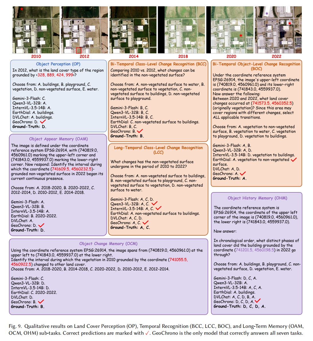
Side-by-side cases reveal how baselines fail: they default to visually salient classes
when the queried target is small, over-select options in multi-choice change recognition, and
anchor memory answers near the reference year instead of tracing back to the actual event.
GeoChrono is the only model that answers all seven perception, recognition, and memory cases
correctly.
Qualitative results on Land Cover Perception (OP), Temporal Recognition (BCC, LCC, BOC), and
Long-Term Memory (OAM, OCM, OHM). GeoChrono is the only model that correctly answers all
seven tasks.
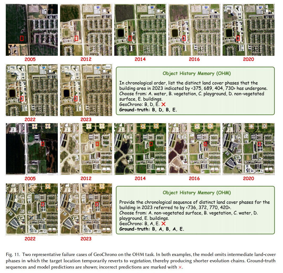
GeoChrono is not perfect either. On Object History Memory, when the ground-truth evolution
chain reaches length four or above, it exhibits phase omission: brief reversions to
vegetation amid an overall development trajectory are skipped, because dormant vegetation in
off-season imagery closely resembles non-vegetated surface. Sharpening this ambiguous class
boundary is a key direction for long-horizon temporal memory.
Representative failure cases on Object History Memory: intermediate vegetation phases are
omitted from the predicted evolution chain.
BibTeX
@misc{li2026geochrono,
  title         = {GeoChrono: Benchmarking and Rethinking Long-Term Temporal
                   Understanding in Remote Sensing},
  author        = {Li, Yujie and Pan, Jiancheng and Wei, Zhiwei and Wang, Jiuniu
                   and Peng, Mugen and Xu, Wenjia},
  year          = {2026},
  eprint        = {2607.15768},
  archivePrefix = {arXiv}
}